

US officials are warning about the possible life-threating impacts of Hurricane Milton as it barrels towards the Florida coast.
Milton is one of the most powerful storms to form in the North Atlantic in recent years.
It comes just two weeks after Hurricane Helene caused substantial damage across the US.
When will Hurricane Milton hit Florida?
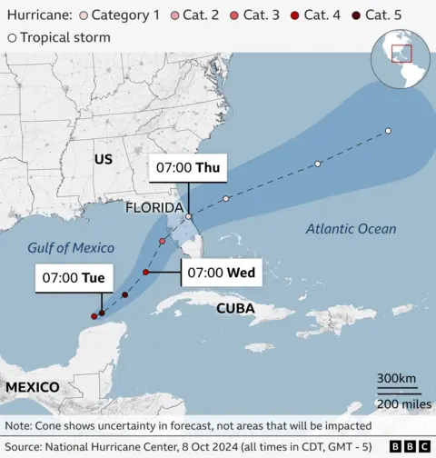
The National Hurricane Center (NHC) expects Milton to make landfall as an “extremely dangerous hurricane” in the US state of Florida on Wednesday night, local time.
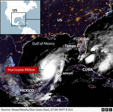
It could strike near the city of Tampa, whose wider metropolitan area has a population of more than three million people.
Forecasters are warning of torrential rain, flash flooding, high winds and possible storm surges – which occur when water moves inland from the coast.
They say Milton could be the worst storm to hit the area in about a century – with a surge of 10-15ft (3-4.5m) possible, and localised rainfall of up to 1.5ft.
Where is Hurricane Milton – and what is its path?
Milton became a category-one hurricane on Sunday and has been steadily moving eastwards, through the Gulf of Mexico, skirting Mexico’s Yucatan peninsula.
BBC weather presenter Chris Fawkes said it had undergone explosive intensification in a 24-hour period, culminating in sustained wind gusts of 200mph (321km/h).
It was put in the most powerful hurricane category – five – though it has fluctuated in strength, and was subsequently downgraded to a category four.
The hurricane is expected to drop in intensity before it arrives on Florida’s west coast.
It is then due to cut straight across the peninsula before ending up in the Atlantic Ocean.

Where are the Hurricane Milton evacuation zones?
Floridians have been told to prepare for the state’s largest evacuation effort in years, with Governor Ron DeSantis warning that a “monster” is on the way.
Most counties are in an official state of emergency, and evacuations have been ordered up and down Florida’s west coast.
Disaster management authorities have issued a list and map of the evacuation orders.
Airports in Milton’s expected path have announced closures, and queues of traffic have been observed as people start to leave their homes.
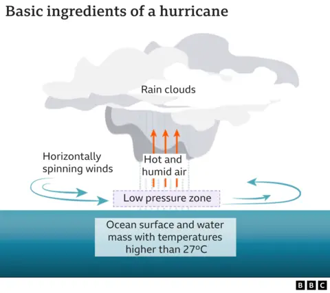
What is a hurricane and how do they form?
Hurricanes – sometimes known as cyclones or typhoons – are a type of tropical storm that form in the North Atlantic. They bring strong winds and heavy rain.
When ocean air is warm and moist, it rises, and then starts to cool – which causes clouds to form.
Sometimes this rising air can move away at the top of the hurricane more quickly than it can be replaced at the surface, causing the surface pressure to fall.
The falling pressure causes the winds to accelerate with more air then getting pulled in as the hurricane strengthens.
The National Oceanic Atmospheric Association (Noaa) predicted that the 2024 hurricane season would be more active than usual. Rising average sea level temperatures due to human-caused climate change were partly to blame, it said.
What is a category five hurricane?
Category five hurricanes are considered “catastrophic” by the National Oceanic Atmospheric Association (Noaa).
They carry wind speeds greater than 155mph (249km/h) and can cause “very severe and extensive damage”.
The US government agency urges “massive evacuations” in residential areas near shorelines, since a category-five hurricane can also bring storm surges that exceed 18ft (5m) and destroy many homes.
Trees and power lines can also be downed, causing the isolation of residential areas and lengthy power cuts. Noaa says affected areas can be left uninhabitable for weeks or months.
Which were the US’s worst category-five hurricanes?
A database from Noaa shows that at least 40 storms in the Atlantic have reached category-five status since 1924, though only four have actually hit land at that strength. Here are some of the most damaging:
Hurricane Camille
Camille crashed into Mississippi in 1969, producing a peak storm surge of 24ft and destroying almost everything along the coast.
It killed 259 people, most of them in Virginia, and caused about $1.4bn (£1.06bn) in damage.
Hurricane Andrew
Hurricane Andrew decimated southern Florida in 1992 with sustained wind speeds of up to 165mph and gusts as high as 174mph.
It claimed 26 lives directly and was blamed for dozens of other deaths. After causing $30bn in damage, it was considered the costliest natural disaster in US history at the time.
Hurricane Michael
Hurricane Michael slammed into Florida in 2018 with 160mph wind speeds and was the strongest storm to make landfall in the Sunshine State.
At least 74 deaths were attributed to the storm – 59 in the US and 15 in Central America – and Michael caused an estimated $25.1bn in damage.
Lower-category storms
Milton comes less than two weeks after Hurricane Helene hit the US as a category-four storm, killing more than 200 people and becoming the deadliest hurricane to strike the US mainland since Hurricane Katrina in 2005.