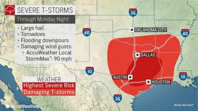
- Cities such as Dallas, Houston and Austin are all in the area of greatest risk into Monday night.
- Flash flooding is also a concern in many of the same locations facing the threat of severe storms.
Dangerous storms are in the forecast for portions of the southern U.S. over the next three days, forecasters warned, and all modes of severe weather are possible, including multiple tornadoes that have already touched down in Texas and Oklahoma.
Dallas, Houston and Austin are all in the area of greatest risk into Monday night, the Storm Prediction Center said.
A tornado touched down around 3:41 p.m. Monday in Jacksboro, Texas, a city of about 5,000 people northwest of Fort Worth, according to Accuweather. The tornado damaged mobile homes and trees near the city, the National Weather Service said, and NBC 5 reported Jacksboro High School and the city’s animal shelter were both damaged.
Multiple highways in Jack County were closed due to downed trees and debris, the Texas Department of Transportation Fort Worth District tweeted.
Another tornado struck Madisonville, about 100 miles of Houston, on Monday night, according to the National Weather Service.
A line of strong thunderstorms advancing toward the Interstate 35 corridor that runs between San Antonio and Austin broke into multiple tornadoes Monday afternoon.
WHAT IS A TORNADO? Everything you need to know about these violent storms
A confirmed tornado reached the ground in Luling, between Austin and San Antonio, according to the National Weather Service. Another touched down in Round Rock, north of Austin, the Williamson County Office of Emergency Management said, in addition to a “massive tornado” east of Round Rock, near Taylor.
Wind and downed trees tore through the roofs of dozens of Round Rock houses and a few businesses east of Interstate 35 and north of Texas 45.
“I thought I was going to die,” said Michael Talamantez, whose Round Rock house was destroyed on Stratford Drive after a tornado touched down.
After the tornado, Round Rock lost some power on the east side of town but officials aren’t sure how many people are affected.
Multiple cars appeared significantly damaged at Kalahari Resort in Round Rock, KVUE fixed cameras showed. They appear to have been tossed and windows shattered.
The city of Elgin, east of Austin, saw major damage and some injuries, according to officials. Elgin police reported at least four injuries, including a rescue underway of two people in a collapsed structure. One person also has been taken to a hospital in Austin.
Elgin city manager Bert Cunningham said the worst damage was east of the town, with as many as four entrapments reported.
Forecasters said the storms could also create ping-pong-ball-sized hail.
The storm traveled north to Oklahoma on Monday evening, creating a tornado that has caused “extensive damage,” Accuweather said. The weather news service reported that the southern city of Kingston was hit with a quarter-mile-wide tornado around 6:30 p.m., creating a damage path of almost 1,300 feet.
A tornado watch was issued for portions of central and eastern Texas and southeast Oklahoma into Monday night , meaning weather conditions are ripe for more tornadoes to form.
“This is a volatile weather pattern, and we’ve seen these types of storm systems previously produce damaging, dangerous and highly impactful severe weather and flooding,” AccuWeather chief meteorologist Jonathan Porter said.
Over customers are without power in Texas and Oklahoma as of Monday night, according to the website poweroutage.us
Forecasters say the volatility could produce strong and long-lived tornadoes, some of which could strike under the cover of darkness.
The National Weather Service in Houston said that “today and tonight remain a time to stay up to date with the latest forecast information and to ensure that you have multiple ways to receive weather warnings. Assess your severe weather plan and ensure that you have a safe location to go to should a warning be issued for your area.”
Flash flooding is also a concern in many of the same locations facing the threat of severe storms, Weather.com said.
The storm system that left widespread damage and some injuries in its wake drifted into Louisiana, Mississippi and Alabama on Tuesday, possibly triggering “a regional severe weather outbreak,” the Storm Prediction Center said.
Cities such as New Orleans and Baton Rouge, Louisiana, and Jackson, Mississippi, are all in the zone of greatest risk.
The threat of severe storms will persist through the morning and into the overnight hours, Weather.com said, and heavy rain and flooding could also hit portions of the Ohio Valley into the South.
The final day of this severe weather outbreak will be Wednesday. The states in the greatest risk area include much of the Carolinas, Georgia and northern Florida. Damaging winds, large hail and a few tornadoes could hit these areas, Weather.com said.
Contributing: Roberto Villalpando, Claire Osborn, Tony Plohetski; Austin American-Statesman


