

In a year that has already seen more than 300 tornadoes and 31 deaths, deadly and dangerous tornadoes like the ones that tore through Arkansas and Illinois on Friday are forecast to continue on Tuesday and again the following weekend.
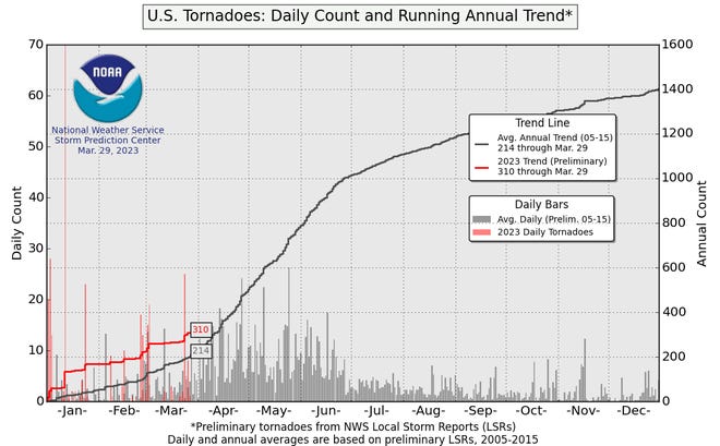
In fact, with 313 tornadoes so far, according to Storm Prediction Center data, it was the third-most-active start to a year on record in the U.S., even before Friday’s violent weather. Last week’s devastating outbreak in the South, which killed more than 20 people in Mississippi and Alabama, followed several previous outbreaks.
“We should be at about 200 tornadoes for today’s date,” Victor Gensini, associate professor at Northern Illinois University, told USA TODAY on March 30. “So we’re running about 100 tornadoes above average, and we have been the entire year.”
Tornado warning:Twisters hitting more frequently and dealing more deaths in the South
Tornado activity is expanding:Southern states see more twisters than ever
What happened Friday?
A low pressure system moving in from the west, with warm dry air behind it and warm, humid air flowing northward to the east from the Gulf of Mexico created a classic set up for severe storms and tornadoes.
Severe storms began forming by late morning, forcing the National Weather Service to issue its first “high risk” warning of the year.
At least three tornadoes were confirmed by mid-afternoon, in addition to damaging high winds and huge hail. Meanwhile, blizzard conditions were reported in South Dakota.
What’s the forecast for Tuesday?
A similar pattern is expected to set up Tuesday, amplified by greater heat and humidity, increasing the risk for severe weather, Gensini said.
If you wanted to draw a textbook severe weather configuration, “this would certainly be it,” he said. Between dry conditions to the west, and hot, wet conditions to the east, he expects to see a “pretty broad area of real estate” at risk on Tuesday afternoon and evening.
A “powerhouse jet stream” moving in from the Plains was moving Friday’s storms at highway speeds, and a similar effect is expected Tuesday. Those kinds of high winds tend to increase the risk for twisters that stay on the ground for a long time, such as the March 24 tornado that devastated Rolling Fork, Mississippi.
Yet another severe weather outbreak is possible the weekend of April 8-9.
“You can certainly take it to the bank” that tornado activity through April 9 will be “way above average,” Gensini said. “We’re going to have more casualties. … It’s just a matter of exactly where at this point.”
It’s crucial for residents to pay close attention to local meteorologists and to have a way to receive timely weather warnings, especially since many tornadoes occur at night.
What is a tornado emergency?
A step above a tornado warning, issued by the National Weather Service in “exceedingly rare” situations, when:
- A severe threat to human life or catastrophic damage is imminent or ongoing.
- Visual or radar evidence such as a reliable source confirms a tornado or a radar picks up the signature of a ball of debris inside the tornado.
Before-and-after the tornadoes:Maps and satellite images show aftermath in Mississippi, Alabama
Why has 2023 been such an active year?
The large-scale weather pattern has been very favorable for tornadoes, said Matt Elliott, meteorologist-in-charge at the Storm Prediction Center. He added the fading La Niña has been a major factor.
Gensini agreed, noting even though we’re no longer officially in a La Niña, “the atmosphere is kind of still feeling the effects of the La Niña with this very active storm track. We’ve had this very active storm track where every few days we see one of these big upper-level lows.”
La Niña, a natural climate pattern marked by cooler-than-average sea water in the central Pacific Ocean, affects weather in the U.S. and around the world.
Elliott said that the top five most active tornado seasons on record in the U.S. have all been during La Niñas.
Another factor has been the unusually warm water temperatures in the Gulf of Mexico, which have been 2-4 degrees Celsius warmer than average, Gensini said.
Calling it “bath water,” he said the Gulf provides the moisture, heat and energy that’s needed for severe thunderstorms to form.

Will 2023 be an above normal year for tornadoes?
It’s too soon to say for sure, said Harold Brooks with NOAA’s National Severe Storms Laboratory. But with the severe weather shaping up over the next 10 days, chances may be increasing.
“A busy first three months of the year doesn’t always mean the rest of the year will have above normal tornado activity,” Brooks said.
In 2021, the year started as one of the busiest on record, above normal through March 2. Then, other than one two-day outbreak in April, “things shut down.” In 2003, the reverse was true, he said. “We were way below normal on the 2nd of May and by the 10th of May, we were way above normal.”
However, Brooks said, if you’re well above normal by the end of April, the year will generally be above normal as a whole.