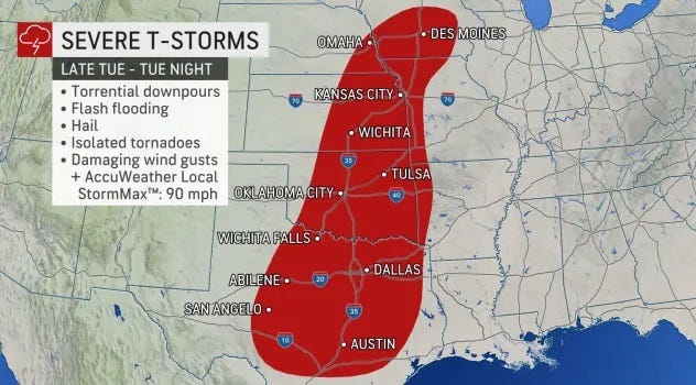
- On Tuesday evening, the greatest risk area for severe thunderstorms includes states from Iowa to Texas.
- Wildfires are also possible across the southern Plains on Tuesday.
- On Wednesday, the risk area for severe storms shifts into the Deep South, including Louisiana, Mississippi and Alabama.
Another multi-day severe weather outbreak is on tap for the central, southern and eastern U.S. this week.
Storms are expected to fire up Tuesday across the central U.S., but the day with the highest risk for severe weather will be Wednesday in the Deep South, forecasters said.
“Residents in portions of the South still reeling from last week’s bout of destructive weather may find themselves in the path of Mother Nature’s wrath once again this week,” AccuWeather meteorologist Mary Gilbert said.
More than 23 million people are at risk for some type of severe weather Tuesday, and the number grows to more than 55 million Wednesday, the Storm Prediction Center said. On Thursday, 20 million people could see severe weather.
WHAT IS A FLASH FLOOD WATCH OR WARNING?Here’s what to know about this deadly weather hazard
Tuesday: Texas to Iowa
On Tuesday evening, the greatest risk area for severe thunderstorms includes states from Iowa to Texas. The hazards associated with the storms are frequent lightning, severe wind gusts, hail and a few tornadoes, according to the National Weather Service.
“Portions of central and northern Texas, as well as Oklahoma and Kansas, can be in the bull’s-eye of the isolated tornado risk,” Gilbert said.
WHAT IS A TORNADO?:Everything you need to know about these violent storms
Wildfires are also possible across the southern Plains on Tuesday. “A significant wildfire outbreak is likely across the southern High Plains today where high winds and very dry conditions will promote extremely critical fire weather,” the National Weather Service warned.
Wednesday: Deep South
On Wednesday, the risk area for severe storms shifts into the Deep South, where states such as Louisiana, Mississippi and Alabama are at highest risk, the Storm Prediction Center said. “All severe hazards are possible, including significant gusts over 75 mph and strong (EF2+) tornadoes,” according to the Center.
An EF2 tornado has wind gusts of 111 to 135 mph.
WATCHES, WARNINGS AND THE EF SCALE:How the National Weather Service talks tornadoes
Cities such as Baton Rouge, Louisiana; Jackson, Mississippi; and Tuscaloosa, Alabama, could see severe storms Wednesday.
Flash flooding will also be a concern Wednesday and Wednesday night, AccuWeather said, especially because rivers remain at fairly high levels after the last outbreak of rain and storms.
Thursday: Mid-Atlantic, Southeast
“There could be a continuation of severe storms from this system in the East on Thursday in one or two rounds,” Weather.com said. “Damaging wind gusts would be the primary concern from any severe storms that develop from portions of the mid-Atlantic into the Southeast.”


